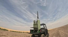
The Ukrainian-Estonian company Farsight Vision presented a navigation module for unmanned ground vehicles (UGVs). It combines a laser sensor with 3D data from the FSV Platform and helps UGVs navigate when there is no GPS signal.
How it works
- Before deployment, a 3D model of the area is created on the FSV Platform. Sensor data is then overlaid onto this model. The platform builds such models from drone aerial photography and video. It converts media into orthophotos and 3D models, and also operates without GPS.
- While moving, the vehicle scans the space around it. The module builds a point cloud in real time that reveals obstacles, pits, slopes, and other terrain features.
- The system continuously compares sensor data against the pre-built model. If GPS is lost and the vehicle loses orientation, the 3D model and point cloud help restore spatial orientation more quickly. In other words, the UGV’s position can be determined by matching the observed terrain against the ready-made model.
- Control remains familiar: the operator works through a ground station, while the FSV App provides an additional 3D view of the route and surrounding terrain. The user sees the map and the current state of the route in real time.
Why this matters
At the front, UGVs face a dual problem: GPS is jammed, and complex terrain creates risks for equipment. Moreover, UGVs are currently often accompanied by a reconnaissance drone that shows the operator the route. CEO Viktoriia Yaremchuk says the company’s goal is to eliminate the need to launch a reconnaissance drone solely to escort a UGV, as this creates unnecessary risk and resource expenditure.
By the end of 2026, the company plans to implement autonomous UGV return to the point of communication loss or to a designated base several kilometers away. Further plans include scaling this capability to 30–40 km at the platform’s maximum speed. The return-to-home function is critical for UGVs: loss of communication on the contact line often means losing the vehicle.
Farsight Vision was founded in 2023 by Viktoriia Yaremchuk and Volodymyr Nepiuk. The UGV module continues the line of GPS-independent navigation solutions. Previously, FSV Navigator was introduced — a navigation module for drones that helps maintain a stable route in the absence of GPS. There is also FSV Mapper, an autonomous device that pre-processes media and transmits it to the platform.